If you are interested in more information about the Pacific Seacraft Flicka 20 sailboat beyond what this blog has to offer, check out the following links. There are some great pictures, specs, reviews, articles, newsletters and more.
Tom Davison and Dennis Pratt have published a newsletter called Flicka Friends since 1995 that provides a plethora of information about Flickas and their travels.
http://www.flicka20.com/flicka-newsletters
Tom was gracious enough to reproduce my “June on the Hook 2017 ” series from this blog as part of his Flicka Friends Newsletter. I very much appreciate his enthusiasm.
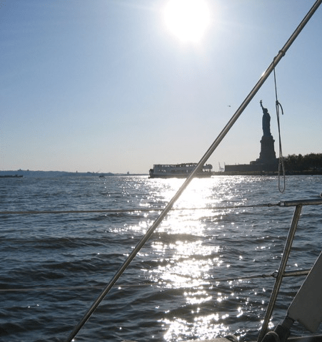
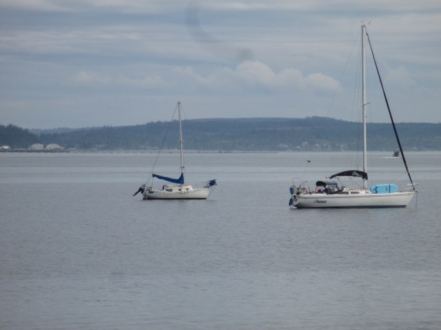
I connected with an old friend from New York and he sent me these photos from 2008. We were out on New York Harbor in a Charles Whitholtz Departure 35 named Naima on a sunny October afternoon. Thank you, Bob.
There is some great footage of Hot Springs Cove in their latest episode. This was the last place we encountered each other during our travels. Their visit coincides with my brief excerpt:
Click the link for more about Tiffany and Lyndon’s story. They in their Niagara 35, and me in my Flicka 20, tag-teamed down the West Coast of Vancouver Island for 11 days in June 2018. They are very nice and generous people, and I enjoyed their company. The Walde’s documentation of the trip is superior to my own, with their digital movie camera and their four hands to my two. (It’s funny how it is called single handing.) Sampaguita and I get some “film extra” time and some audio referencing. Is this proof I actually circumnavigated?
There is another YouTube video from Walde Sailing. The episode shows some awesome panoramic video of Dixie Cove Provincial Park in Kyuquot Sound. It coincides with my blog post:
Wonderful Cove and Wonderful People
In hindsight, this was my favorite anchorage of the 2018 Vancouver Island circumnavigation. It was very protected with good holding. Without VHF reception and a weather forecast, it felt the most isolated. No other boats were heard or seen. The narrow entrances gave a sense of seclusion and cloud cover meeting the mountains added to the other-worldliness and peace.
Click the link for more about Tiffany and Lyndon’s story. They in their Niagara 35, and me in my Flicka 20, tag-teamed down the West Coast of Vancouver Island for 11 days in June 2018. They are very nice and generous people, and I enjoyed their company. The Walde’s documentation of the trip is superior to my own, with their digital movie camera and their four hands to my two. (It’s funny how it is called single handing.) Sampaguita and I get some “film extra” time and some audio referencing. Is this proof I actually circumnavigated?
I attended and volunteered at The Port Townsend Wooden Boat Festival, hosted by the Northwest Maritime Center, on September 8th and 9th, 2018. My motive is to share some positive encounters I had over the weekend. Highlights of my festival experience were Joni Blanchard’s Varnishing Tips and Tricks presentation, meeting Kaci Cronkite, Steve Wystrach’s film on Robert Manry, and Maria Coryell-Martin’s Adventure Sketching workshop. My experience was centered on my volunteer commitments as the Boatyard Stage Manager and wandering the docks. While my personal scope of the festival is narrow, it is intended to highlight how to participate and spectate on an individual level. I do not have a personal or professional connection with these presenters and the first and last time I have met them, was at the festival.
Joni Blanchard’s presentation, “Varnishing Tips and Tricks,” held on Saturday afternoon at the Boatyard Stage, was both entertaining and informative. She clearly knows her subject well and is not only knowledgeable and thoughtful but also has an apparent level of artistry that transcends technique. She presents with a great smile, a down-to-earth manner and is clearly passionate about her craft.
Joni gave thorough and experience-based advice on products, methods, and myths. She brought many visual props to her presentation outlining the varnishing process from beginning to end. These included tapes, cleaners, varnishes, brushes, and umbrellas, to name just a few. Joni not only offered which products and techniques she used, but explained advantages and disadvantages, the when and the why, possible variabilities, common misunderstandings, and the “tips and tricks” only someone with an immense amount of experience can convey. She answered audience questions sincerely and honestly, and if an inquiry was beyond her knowledge, she said so. She wrapped up her workshop with a live demonstration of rolling and tipping.
Whether you are a novice or a professional, I suggest there is something to learn from attending one of Joni’s “Varnishing Tips and Tricks” presentations. Joni also has a book, Tricks, Cheating & Chingaderos: A Collection of Knowledge and Tips for Varnishing/Painting Wooden Boats. While the book is outside of my personal festival experience, based on Joni Blanchard’s presentation, I would suggest it is likely a good acquisition for someone interested in the craft of varnishing.
Saturday evening I was walking the docks with my friend Bob, perusing the wooden boats on hand. We happened to be admiring a 1936 28’ Danish double-ender named PAX, when the owner, Kaci Cronkhite, returned to her boat. She asked if we would like to come aboard. Like any curious boat enthusiasts, we said, “Yes.” We spent the next 10 minutes chatting with Kaci about PAX’s history and getting a “teaser” synopsis of her book, Finding Pax. She made references to Erskine Childers’, The Riddle in the Sands, a classic I have read and enjoyed, and Finding Pax certainly piqued my interest. When my friend asked for clarification on whether the boat was at one time stolen in California and taken to Canada, Kaci’s reply was, “You’ll have to read the book.” I found Kaci to be an intense personality. A steadfast promoter that is charming, intelligent, inspirational, and with a flare of mystique.
The one event I had planned on attending at the festival was Steve Wystrach’s documentary film, Manry at Sea: In the Wake of a Dream, showing Saturday at 7 pm in the Northwest Maritime Center. This would be the Northwest premiere of the film, and I was advised to arrive early for a good seat. This advice turned out to be sound. In 2007 I was loaned Robert Manry’s book, Tinkerbelle. Tinkerbelle is Robert’s inspirational story about crossing the Atlantic Ocean in a 14-foot boat in 1965, from Falmouth, Massachusetts to Falmouth, England. Big adventure in a small boat is always intriguing to me, so when I heard there was now a film, naturally I was interested.
Steve, influenced by the story of Tinkerbelle, and with experience in the film industry, recognized that Robert had a 16-mm movie camera in his list of gear for Tinkerbelle. He wondered what happened to the footage. Inspired, Steve eventually made contact with Manry’s family who still had that footage and more, and 21 years later, the film is complete.
The documentary did not disappoint. Steve put into a film much of what Robert put into words. Steve highlighted more of Robert’s personality, great smile, and personal history. There is video taken by Robert while at sea and media coverage of the hype. There are also recent interviews with family, acquaintances, and experts.
If you are a non-sailor, Steve’s film will give you all you may want to know about Robert’s story. If you are a sailor, you will want to read the book in addition to the movie. It is a terrific account of an incredible voyage.
Last, but not least, Maria Coryell-Martin presented Adventure Sketching at the Boatyard Stage on Sunday at noon. I was uncertain what and who to expect, and the Sunday weather turned a little rainy and a lot windy. However, Maria was not intimidated by such elements and showed the skill of improvisation as we adjusted the Stage to contend with the weather conditions.

Maria’s presentation was maritime focused and designed for the person who wished to capture a scene on paper, regardless of skill and experience. Her delivery was fun, animated and energetic. She projected her voice well, and every member of the mostly adult audience was engaged. Maria discussed various techniques and approaches to sketching. For one, observing the subject matter by squinting to simplify it. Another was interpreting and drawing lines by using broad strokes or in contrast, by using continuous lines. She emphasized the importance of contrasting shades and gave ideas for conveying these. She reviewed materials for journaling and traveling and always reminded people that this was meant to be fun and there was no “wrong.” She provided plenty of paper and pencils for the audience and followed every technical suggestion with an exercise for the audience. This was a key to her audiences engagement.
Maria is a very talented artist and an excellent teacher. Her ability to captivate the audience, young and old, is exceptional and her skills, apparent. I would recommend her workshops to anyone interested in sketching. Whether you are a dabbling novice or a more seasoned artist, I suspect you will find her energy is exhilarating and your time spent, worthwhile.
While I missed many great presentations and events at The Port Townsend Wooden Boat Festival, I did not miss having a great experience. To give an accurate and detailed account of the entire festival would be exhausting and frankly, impossible. The success of the festival depends on hundreds of dedicated staff, faculty, and volunteers and is the city’s biggest weekend. I focused on how an individual can make a contribution to the whole and enhance their own experience. If you have been thinking of attending the Port Townsend Wooden Boat Festival, I recommend it. If you have an opportunity to volunteer, your efforts will be appreciated and shape your experience. It took me eight years to attend the annual festival and glad I finally did.
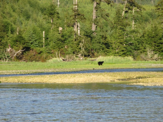
There is another YouTube video from Walde Sailing. This episode shows some really great video of black bears in the wild! It also coincides with my blog post:
I’d Rather be Anchoring
and
Vancouver Island Wildlife
Click the link for more about Tiffany and Lyndon’s story. They in their Niagara 35, and me in my Flicka 20, tag-teamed down the West Coast of Vancouver Island for 11 days in June 2018. They are very nice and generous people, and I enjoyed their company. The Walde’s documentation of the trip is superior to my own, with their digital movie camera and their four hands to my two. (It’s funny how it is called single handing.) Sampaguita and I get some “film extra” time and some audio referencing. Is this proof I actually circumnavigated?
There is another YouTube video from Walde Sailing. Click the link for more about Tiffany and Lyndon’s story. They in their Niagara 35, and me in my Flicka 20, tag-teamed down the West Coast of Vancouver Island for 11 days in June 2018. They are very nice and generous people, and I enjoyed their company. The Walde’s documentation of the trip is superior to my own, with their digital movie camera and their four hands to my two. (It’s funny how it is called single handing.) Sampaguita and I get some “film extra” time and some audio referencing. Is this proof I actually circumnavigated? The Chicken Alfredo was delicious, the Cinnamon Rolls were even better, and we did not have any trouble finishing the bottle of homemade Blueberry Wine. Check out Walde Sailing’s latest YouTube video.
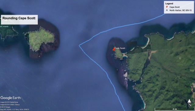
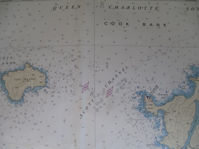
Rounding Cape Scott
I departed Bull Harbor with a destination of Quatsino Sound on June 9th, 2018. While I left before the Walde’s, they soon passed me as I hung back and waited for slack water over the Nahwitti Bar. Published information suggests transiting the bar at the high ‘stand of the tide’ and, reconsider, with heavy wind or ocean swell. On this day, I crossed at the recommended time, and it was a non-event.
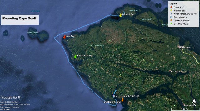

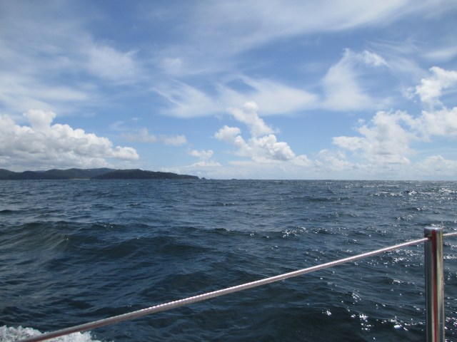
I continued on under sail, which meant slow and less consistent speeds. A series of squall lines from the south passed over, each giving me a boost, and at one point, hailstones pelted the boat. I was riding an ebb tide, the south wind continued to build on the bow, and chop began to develop. I calculated the distance I needed to travel and determined a need to move faster. It was a necessity to round Cape Scott before the tide reversed to flood, so I started the outboard motor to make better time. On the way, I encountered the humpback whales the Walde’s caught on camera, though the Walde’s were far ahead of me by that time. (Did you watch the video?)

The wind and chop continued to build, though the squall lines had passed, and the sun was shining. My strategy was to round the Cape with the last of the ebb tide to mitigate what I expected to be turbulent waters. If I could not get around before the flood set in, it would be a very slow and uncomfortable rounding. I just did not have time for this and may have even needed to return to Bull Harbor, 18 miles away. I was happy for some prior ocean experience in Sampaguita when I sailed up the West Coast of Vancouver Island in 2016. Though the swell and chop made for uncomfortable seas, often coming together in pyramids of water, I was not intimidated and beyond my experience.
I was towing my inflatable kayak, which was a calculated decision. In the boating community, there could be significant controversy around this choice. First, my decision was based on the kayak causing very little drag. Second, I have a long tow rope. Third, as a Flicka 20 has limited storage and deck space, there is not a life raft (more controversy.) The inflatable kayak would double as my life raft if needed, but only if it was already inflated. Once inflated, it neither fits in or on the boat. If it untethered, which is the argument against towing a dinghy in such seas, it would likely be lost to me forever. I had the towing rope uncoiled to its full length, which was about 40 feet. This would keep it at least one wavelength back and limit the snapping force of the line becoming suddenly taut. In the steep chop and pyramid seas, the kayak would sometimes launch off of the waves. Once I was committed to the towing decision and rounding the Cape, there was no making a different choice.
The outboard motor ventilated twice. This was caused by the propeller lifting out of the water when short, steep waves raised the stern. The reduced resistance caused the engine to quickly over-rev. When the stern plunged down into the trough, it submerged the over-revved propeller and bogged the motor down. This is terrible for the motor’s health. To minimize this, I tacked through Scott Channel. This meant I was taking the waves at a 45-degree angle rather than straight on. I would travel a greater distance and take more time, but this choice seemed far better than damaging the motor when I needed it most.
Alas, I made it around the Cape and away from the clutches of the flooding tide. I recalled from my previous ocean experience (yes, I had forgotten) that swells and chop reduced my motive power by about 26%. Instead of a top speed of 5.7 knots, it was more like 4.2 knots. This equates to 36% more fuel AND 36% more time used when traveling on the ocean.
Example: 10 hours @ 5.7 knots = 57 NM –then— 57 NM / 4.2 knots = 13.57 hours
Since fuel on a boat is more accurately correlated to time traveled at any given rpm, rather than mileage or speed at that same rpm, we see how the math works out. Follow? These changes of efficiencies are caused by the energy being lost to pitching, rolling and traveling the extra distance added on by going up and down the swells. What you gain on the downhill, you lose on the uphill. Not only can you see this in your speed, but you can hear it in the laboring motor.


As the Walde’s mention in their video, the Southerly swell and wind made a stopover at Sea Otter Cove, and any of the other coves along this section of the coast, out of the question. Southerlies run directly into these coves. While passing a mile or so off Sea Otter Cove, I could see the large swells breaking over the submerged reef just outside the entrance and to the northwest of Winifred Islands. The immense power was intimidating, and if caught in these breaking swells, complete annihilation could be expected. No joke. With no refuge, I was obliged to make it to Quatsino Sound. I also quickly realized I was in a race against the setting sun. Because I had to time the earlier crossing of the Nahwitti Bar for 10:10 am, I lost a few hours of navigable light in the morning. The race was on……at about 4.2 knots…..with hours still to go.


I approached Quatsino Sound as the sun was setting. I turned on the navigation lights and put on my headlamp, its red light for night vision. The paper chart in one hand, the tiller in the other, I rounded Quatsino Lighthouse on Kains Island. To avoid Robson Rock, invisible to me in the fading light, I stayed in close to Kains Island. Two fishing trawlers working in the area piloted around me as I made my way. It was a nerve-wracking experience, not knowing if they were dragging nets or lines. I accepted their right-of-way, but with the light dwindling, I pressed on. My destination was the North Harbour anchorage behind Matthews Island in Forward Inlet. I chose the shortest route, a narrow channel to the west of Hunt Islets and Matthews Island. With the deeper water of the high tide on my side and staying in the channel’s center by judging the shadows and silhouettes, I made it safely through. Almost there, I pulled out my searchlight in an effort to find the two red nuns indicated on the chart off the west side of Matthews Island. They were not to be found, so I just gave the area a wide berth. I could see the Walde’s Niagara 35 anchored in the harbor. I used them as a reference point to select my own spot, dropping my hook in about 30 feet of water.
I arrived in North Harbour as the last bit of twilight faded to black. After a long day, it was a relief to be at anchor. The day’s experience highlights two reasons I plan my expeditions for June. One, to take advantage of the longest days of the year. Another, there are fewer boats out traveling. What if I arrived and the anchorage was full? 14 hours and 31 minutes of travel, a distance of 58.19 NM, the anchor was down and secure at 11:05 pm. Exhausted, the next day was destined a rest day. I did the “putting the boat to bed” chores (well, most of them) and heated up a much needed can of chili. After my fill, I crawled into bed and quickly fell asleep. What a day!

The Walde’s at Anchor in North Harbour. I used them as a reference point while anchoring in the dark the night before.

Qauatsino Sound with a Van Gogh overlay 😉

Quatsino Sound with a Lauren Gandursky overlay 😉
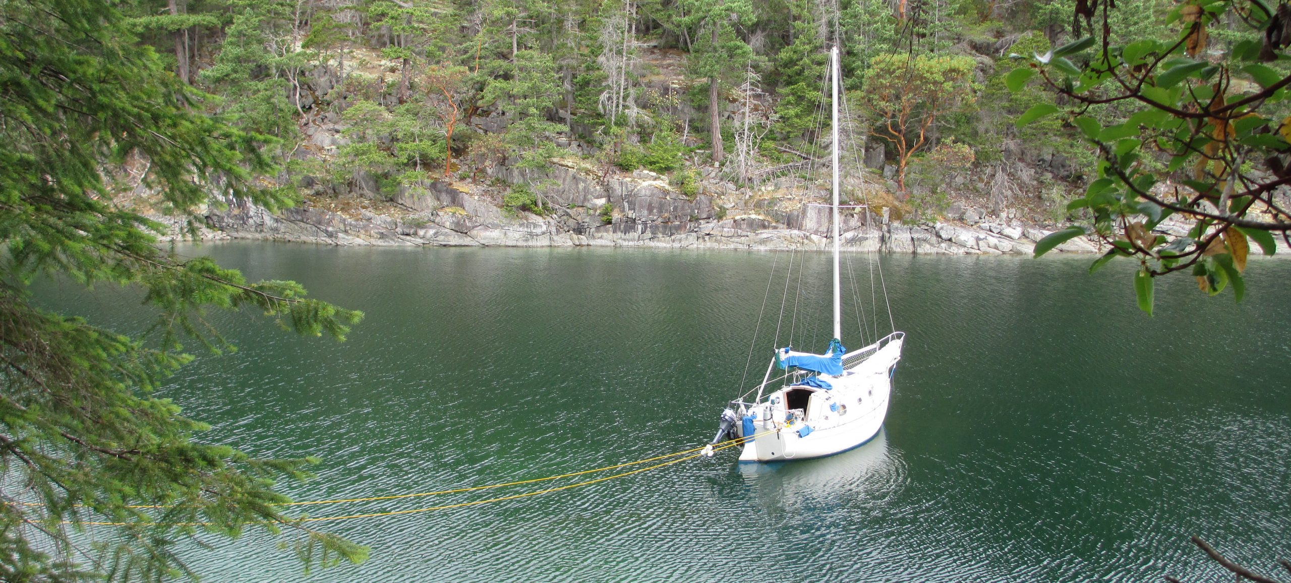
Bull Harbour is a jumping off spot on the northern tip of Vancouver Island. This is the last safe harbor before crossing the Nahwitti Bar and rounding Cape Scott, especially in June when the summer weather hasn’t settled in yet. On June 8th, this is where I met Lyndon and Tiffany Walde of Walde Sailing. The video below is from there weekly episodes which they post on YouTube. You will see Sampaguita making a cameo appearance from time mark 13:09 until the end of the video. Well, a cameo is a bit of a stretch, but I can at least say she is a film extra!
Actually, Bull Harbor is on Hope Island, just off the northern tip of Vancouver Island and represents the farthest north I have yet to sail with Sampaguita. Wikipedia claims the population is between 2-20 people. It is First Nation land and as it was late in, and early out for me, I did not go ashore. The anchoring here is excellent in about 25 feet of water with a muddy bottom.
The following morning I left Bull Harbor and timed the crossing of Nahwitti Bar which is just west of Hope Island. The crossing was uneventful on this particular day, but this is one of those spots publishings warn you about. It is recommended you cross at high water slack and to think twice if there is significant wind and/or incoming ocean swell.
On the day I crossed the Bar, June 9, 2018, Sampaguita and I had our longest leg of the nearly 1000 nautical mile journey, at 58.19NM in our effort to make Winter Harbour. It included rounding Cape Scott under less than ideal conditions, taking on the Pacific Ocean and entering the unfamiliar Quatsino Sound and anchoring after dark. However, I will save that story for another post.

The Pier in Bull Harbour from the Rear View Mirror
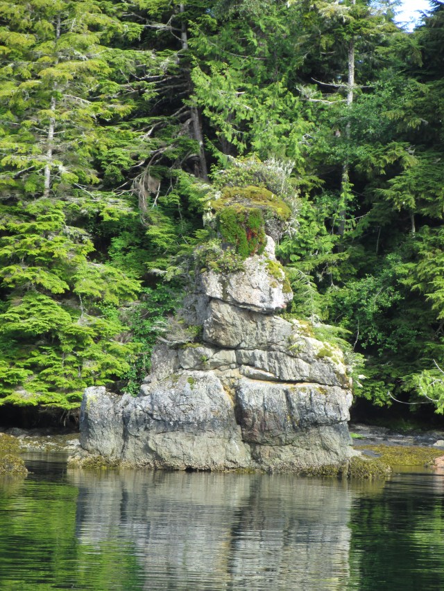
A Sea Stack in the Bull Harbour Channel.

I was rinsing down the anchor gear on deck of Sampaguita, my 1985 Pacific Seacraft Flicka 20, back in my home port when a dock mate walked by. He asked,” how much anchor rode is that?” “300 feet,” I replied. “Do you really need that much?” “Yes, if I anchor in 60 feet of water and I put out 5:1 scope, I do.”

I have used all of it at times. In the Pacific Northwest we can have a 14-foot tidal swing, so what is 40 foot this afternoon might be 54 feet in the evening. 5:1 is a minimum scope ratio for a mostly nylon rode. It does get a little tricky and takes some compromise in a busy anchorage. In a tight spot, I will also use a stern tie. I don’t want to use more than I need for the sake of sharing, and because the more rode out, the more subject to chafe. However, it takes what it takes. I need to sleep well, or rather, I may be so tired I will sleep well. I don’t want to worry about dragging anchor or swinging into others.
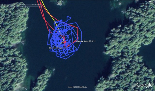
Have I ever dragged anchor? Maybe once…..so far. It may have been just stretching under a massive wind gust. I did not need to reset the anchor. When I swung to the other side of the circle, however, I feel like I was about 5 or 10 feet shy of my previous marks. Below is a GPS track of my anchorage in Klaskino Basin waiting out a storm just north of Brooks Peninsula.

Depths in Meters – It’s Canadian eh?
The Environment Canada weather report kept upping the ante with this front. First a “Gale Warning” then a “Storm Warning.” The last of my notes during the thick of it were:
June 12, 2018 – Time – 1730 – West Coast Vancouver Island North – Storm Warning – SE 30-40 knots w/ SE 50 over headlands – Solander Island (15 NM as the crow flies to the South) – 45 knots, gusting 53. Sartine Island (~40 NM to the North) – 42 knots, gusting 52.
Here’s the story:
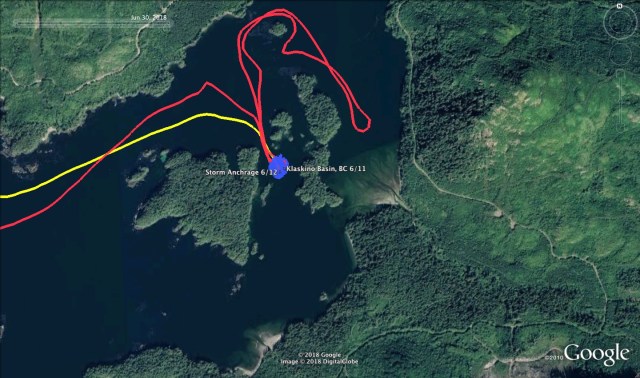
The Waldes, of Walde Sailing (we were buddy boating,) and I arrived at the Klaskino Inlet anchorage late in the afternoon. We had decided, based on our guidebooks, that this would be the best place to wait out the incoming storm forecast for the next day. When we left North Harbor, the wind was light and required motoring out of Quatsino Sound. However, about three miles out, it turned into a great sailing day. We were able to sail around Lawn Point and Scarf Reef, up Newton Entrance, and around Rugged Island. Then, between Martin Rock and Steele Reef and into Scouler Entrance. I had chosen Klaskino Basin to anchor, and the Waldes chose the anchorage to the east. Can you see the red loop in the track? The river delta is where we saw the family of bears I picture in a previous post.


The Sailing Directions mention if the two buoys are not present, do not attempt the entrance. They tend to drift in storms.
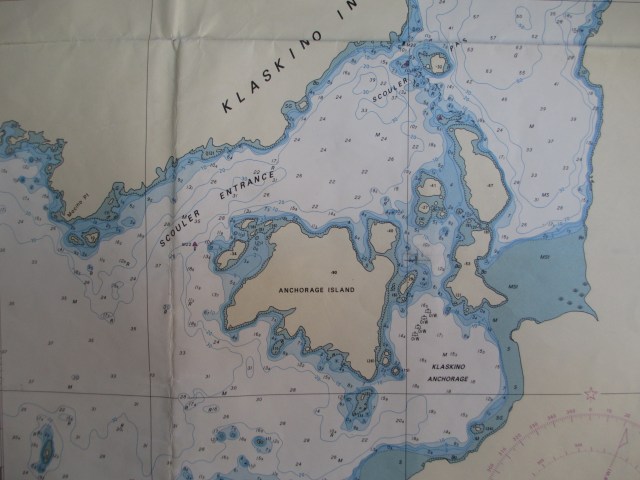
I aimed to put the anchor directly in the center of the basin, where the bottom was thick dark mud and shell. I judge the water depth from the chart and by “feel.” The first tells me the surveyed depth. The second comes from anchoring by hand, sensing when the weight of the anchor touches the bottom, and then when the last of the chain of 30 foot hits too. I then take an approximate measurement from the markers on the anchor rode. I factor in the state of the tide, cross-reference this to the chart, then assess for agreement. Using this method, I estimated the depth to be about 40 foot, took note of the tide level, then let out another 133 feet. I do have a leadline but chose not to use it this time.
After I made a satisfying meal of pasta and tomato sauce, doctored with onions, garlic, spices, and Uli’s dried sausage, the Waldes and I did some bear watching. Then I settled in for an evenings rest. The night was peaceful, and in the morning, I awoke to the calls of many different birds. I’d read this was a migratory stopover for several species. Also, the sound of what I would later learn was a logging truck. At the time though, I thought it was a low flying plane, in the mountains below the cloud cover.
I washed dishes and tidied up as I expected a long day of anchor watch. I also considered setting a second anchor. The winds were forecast from the SE, then shifting to the SW. Instead, I waited to see how the topography affected the wind and was glad I did.
The winds began around 9 am, alternating calms with strong gusts. These strong gusts would come from all directions. This is why I was glad I did not put out a second anchor. The tidal currents were unpredictable too with water flowing in multiple directions. The surrounding topography played a role in all of this. I let out the anchor rode to 160 foot, and then 200 foot.
The boat was sailing around at anchor, and there was more to come. As the day went on, the wind gusts built and the forecast revised. I put my foulies on to stand outside and watch the shore swing by, with an eye for it getting to close. The inflatable kayak was tethered to the stern cleat with a single painter. I was looking at it and thinking, “I really should’ve put a chafe guard on the towing bridle right from the start. Maybe I’ll do that now.” Then I heard the whistle of an approaching gust of wind from the South, followed a few seconds later by the whistle of an approaching gust from the East. The boat heeled to starboard, then to port, and the kayak was lifted three feet out of the water and did a 360-degree roll in the air. “And while I’m at it, I’ll attach the kayak with painters on both ends.”
By the afternoon, I increased the rode length to 225 feet. With the tide, this was oscillating between a 5:1 and 6:1 scope ratio. It was all I dared to put out in the basin. The swing circle was 500 feet, including the length of the boat. I could use the Pythagorean theorem and get a more scientific answer, but the difference from the rode measurement is insignificant. In case I needed to move the boat, I lowered the outboard motor and test started it. With the wind alternating between calms and gusts, I could haul up the anchor and move. If necessary, my escape plan was to relocate to Klaskino Anchorage, just to the south. It was more exposed to the wind, and the depths were greater so my scope ratio wouldn’t improve, but it was less confined. In the Klaskino Basin, every direction was a lee shore. The calms were great, but the gusts were very violent. I could hear the whistling through the trees and see them bending over. Water spray was lifting from the surface, and the parade of wavelets raced across the water. The sea state was never fierce, though I could see the small chop created by the wind against current. Sampaguita wanted to float broadside to the wind so the gusts would make the boat heel over and sail across the basin. I measured the boat’s speed at times over 1 kt.
I inspected my two grab bags and asked myself, “If I had to leave the boat immediately, what would I want to take?” They lacked important items. I gathered more batteries, the backup GPS, cash, water, Larabars, passport, keys, wallet, and the handheld VHF and put them into a third bag. In my present location, I was isolated but not alone. When our positions were in line, I could see the Walde’s boat through the trees. We were likely the only ones around for miles. If one of us were to have trouble, there would not be much the other could initially do, but it wouldn’t be a search and rescue scenario.
The Waldes were having their own anchoring stories. In North Harbor, Quatsino Sound, the morning before, they discovered their anchor was hooked on a mass of heavy discarded line. They spent two hours cutting the anchor free by leaning over the dinghy, swimming mask and snorkel on, with a saw attached to a boat hook. I was to learn later, their anchor dragged during this storm, and they had needed to reset it.
In the late afternoon, there seemed to be an extended lull. I thought, “maybe this is it.” I went below, took my foul weather gear off and was contemplating some warm food. Just after undressing, I heard a gust of wind coming. That I heard it coming as well as I did down below in Sampaguita’s cozy cabin was a sign that it would be massive. The boat heeled to port and sailed to the end of the anchor rode’s slack, then heeled even farther as it came up bow to wind. I heard a throaty, unfamiliar sound come from the bow roller. I quickly looked at the GPS track, and it showed me just outside the circle I had been previously tracking in. I jumped up on deck to see how the boat lay. There was an islet very close to the SW with shoal water around it. Everything seemed to be OK, and the anchor seemed to be holding. Stretch or dragging? With a rush of adrenaline kicked in, I put my foulies back on and started a new shift of anchor watch.
Besides being on the alert for a dragging anchor, other items I had to watch out for was the rode’s lead. The boat not only tacked back and forth across the wind, but it would spin and jibe too. As it sailed around, influenced by the wind and the currents, the anchor rode’s lead changed, putting varying degrees of stress on the bowsprit, platform, and cleats. There is not much I can do about this, but sometimes the rode wanted to foul between the Flicka and the kayak tied alongside (a disadvantage of the two painter system.) Other hazards were around too. The night before and also in the morning, I had spotted a deadhead drifting around in Klaskino Anchorage. I was hoping it would not enter the basin during the storm as I had no interest in tangling with it. This would also be a consideration if I needed to relocate to Klaskino Anchorage.
The weather continued as advertised, until about 11:45 pm. It had been going on for 15 hours. The front passed and the gusts moderated. I went to bed, leaving the GPS tracking. With a red flashlight close by, I could check it whenever I awoke. It wasn’t a great nights sleep, but by morning the weather was clear. I planned to take in the rode as the morning’s low tide progressed. In 21 hours the GPS said I traveled 4.99 NM at anchor. The gear did a great job, even with short scope. The holding in Klaskino Basin is very good in thick mud and shell. With the local topography and currents, it can be an awkward anchorage in heavy winds from the SE.
Sampaguita at rest in Port Townsend. 40-50 ft depth with 250 ft of rode.
One of my wildlife viewing hopes came true on this trip. I was just getting settled at anchor in Klaskino Basin when the Walde’s came into the basin in their dinghy. “Josh, get your camera, there is a family of bears around the corner!” So I got my gear on, slipped into the dinghy with them and we watched three bears foraging for food along the shore. Sweet. When I left 2 days later, I saw another along Mocino Point.
The sea otter has made a good recovery on the West Coast of Vancouver. They can be seen floating on their backs, cracking open shells and eating over the entire range. I am told the crabbing industry has taken a hit as a result. I am not sure if that is because the otters are eating the crabs, or whether the crabs are protected for their food. They are pretty adorable when they are floating on their backs. With over 1 million hairs per square inch, their fur must be amazing.


