I’d Rather be Anchoring

I was rinsing down the anchor gear on deck of Sampaguita, my 1985 Pacific Seacraft Flicka 20, back in my home port when a dock mate walked by. He asked,” how much anchor rode is that?” “300 feet,” I replied. “Do you really need that much?” “Yes, if I anchor in 60 feet of water and I put out 5:1 scope, I do.”

I have used all of it at times. In the Pacific Northwest we can have a 14-foot tidal swing, so what is 40 foot this afternoon might be 54 feet in the evening. 5:1 is a minimum scope ratio for a mostly nylon rode. It does get a little tricky and takes some compromise in a busy anchorage. In a tight spot, I will also use a stern tie. I don’t want to use more than I need for the sake of sharing, and because the more rode out, the more subject to chafe. However, it takes what it takes. I need to sleep well, or rather, I may be so tired I will sleep well. I don’t want to worry about dragging anchor or swinging into others.
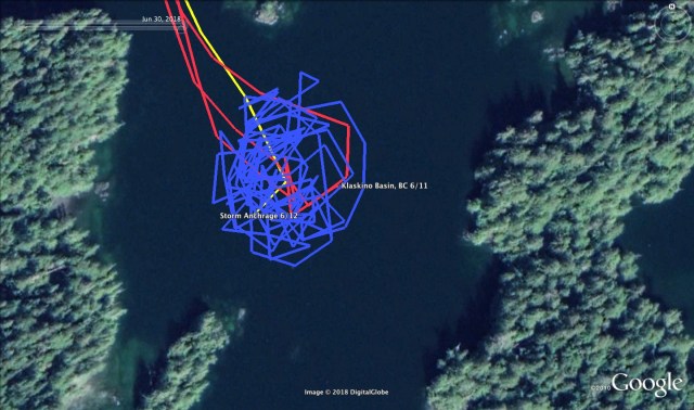
Have I ever dragged anchor? Maybe once…..so far. It may have been just stretching under a massive wind gust. I did not need to reset the anchor. When I swung to the other side of the circle, however, I feel like I was about 5 or 10 feet shy of my previous marks. Below is a GPS track of my anchorage in Klaskino Basin waiting out a storm just north of Brooks Peninsula.

Depths in Meters – It’s Canadian eh?
The Environment Canada weather report kept upping the ante with this front. First a “Gale Warning” then a “Storm Warning.” The last of my notes during the thick of it were:
June 12, 2018 – Time – 1730 – West Coast Vancouver Island North – Storm Warning – SE 30-40 knots w/ SE 50 over headlands – Solander Island (15 NM as the crow flies to the South) – 45 knots, gusting 53. Sartine Island (~40 NM to the North) – 42 knots, gusting 52.
Here’s the story:
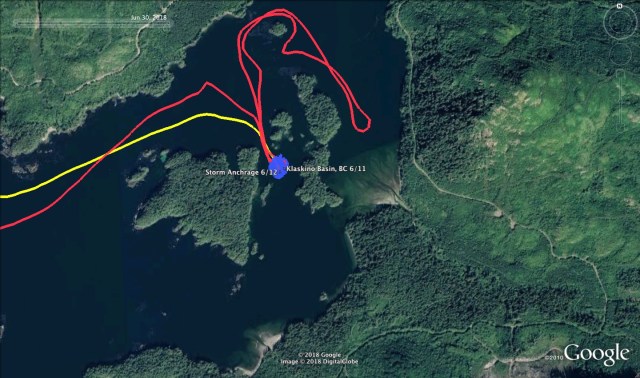
The Waldes, of Walde Sailing (we were buddy boating,) and I arrived at the Klaskino Inlet anchorage late in the afternoon. We had decided, based on our guidebooks, that this would be the best place to wait out the incoming storm forecast for the next day. When we left North Harbor, the wind was light and required motoring out of Quatsino Sound. However, about three miles out, it turned into a great sailing day. We were able to sail around Lawn Point and Scarf Reef, up Newton Entrance, and around Rugged Island. Then, between Martin Rock and Steele Reef and into Scouler Entrance. I had chosen Klaskino Basin to anchor, and the Waldes chose the anchorage to the east. Can you see the red loop in the track? The river delta is where we saw the family of bears I picture in a previous post.


The Sailing Directions mention if the two buoys are not present, do not attempt the entrance. They tend to drift in storms.
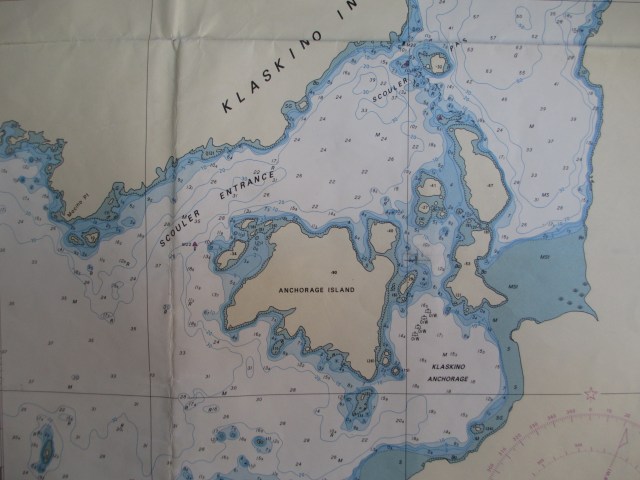
I aimed to put the anchor directly in the center of the basin, where the bottom was thick dark mud and shell. I judge the water depth from the chart and by “feel.” The first tells me the surveyed depth. The second comes from anchoring by hand, sensing when the weight of the anchor touches the bottom, and then when the last of the chain of 30 foot hits too. I then take an approximate measurement from the markers on the anchor rode. I factor in the state of the tide, cross-reference this to the chart, then assess for agreement. Using this method, I estimated the depth to be about 40 foot, took note of the tide level, then let out another 133 feet. I do have a leadline but chose not to use it this time.
After I made a satisfying meal of pasta and tomato sauce, doctored with onions, garlic, spices, and Uli’s dried sausage, the Waldes and I did some bear watching. Then I settled in for an evenings rest. The night was peaceful, and in the morning, I awoke to the calls of many different birds. I’d read this was a migratory stopover for several species. Also, the sound of what I would later learn was a logging truck. At the time though, I thought it was a low flying plane, in the mountains below the cloud cover.
I washed dishes and tidied up as I expected a long day of anchor watch. I also considered setting a second anchor. The winds were forecast from the SE, then shifting to the SW. Instead, I waited to see how the topography affected the wind and was glad I did.
The winds began around 9 am, alternating calms with strong gusts. These strong gusts would come from all directions. This is why I was glad I did not put out a second anchor. The tidal currents were unpredictable too with water flowing in multiple directions. The surrounding topography played a role in all of this. I let out the anchor rode to 160 foot, and then 200 foot.
The boat was sailing around at anchor, and there was more to come. As the day went on, the wind gusts built and the forecast revised. I put my foulies on to stand outside and watch the shore swing by, with an eye for it getting to close. The inflatable kayak was tethered to the stern cleat with a single painter. I was looking at it and thinking, “I really should’ve put a chafe guard on the towing bridle right from the start. Maybe I’ll do that now.” Then I heard the whistle of an approaching gust of wind from the South, followed a few seconds later by the whistle of an approaching gust from the East. The boat heeled to starboard, then to port, and the kayak was lifted three feet out of the water and did a 360-degree roll in the air. “And while I’m at it, I’ll attach the kayak with painters on both ends.”
By the afternoon, I increased the rode length to 225 feet. With the tide, this was oscillating between a 5:1 and 6:1 scope ratio. It was all I dared to put out in the basin. The swing circle was 500 feet, including the length of the boat. I could use the Pythagorean theorem and get a more scientific answer, but the difference from the rode measurement is insignificant. In case I needed to move the boat, I lowered the outboard motor and test started it. With the wind alternating between calms and gusts, I could haul up the anchor and move. If necessary, my escape plan was to relocate to Klaskino Anchorage, just to the south. It was more exposed to the wind, and the depths were greater so my scope ratio wouldn’t improve, but it was less confined. In the Klaskino Basin, every direction was a lee shore. The calms were great, but the gusts were very violent. I could hear the whistling through the trees and see them bending over. Water spray was lifting from the surface, and the parade of wavelets raced across the water. The sea state was never fierce, though I could see the small chop created by the wind against current. Sampaguita wanted to float broadside to the wind so the gusts would make the boat heel over and sail across the basin. I measured the boat’s speed at times over 1 kt.
I inspected my two grab bags and asked myself, “If I had to leave the boat immediately, what would I want to take?” They lacked important items. I gathered more batteries, the backup GPS, cash, water, Larabars, passport, keys, wallet, and the handheld VHF and put them into a third bag. In my present location, I was isolated but not alone. When our positions were in line, I could see the Walde’s boat through the trees. We were likely the only ones around for miles. If one of us were to have trouble, there would not be much the other could initially do, but it wouldn’t be a search and rescue scenario.
The Waldes were having their own anchoring stories. In North Harbor, Quatsino Sound, the morning before, they discovered their anchor was hooked on a mass of heavy discarded line. They spent two hours cutting the anchor free by leaning over the dinghy, swimming mask and snorkel on, with a saw attached to a boat hook. I was to learn later, their anchor dragged during this storm, and they had needed to reset it.
In the late afternoon, there seemed to be an extended lull. I thought, “maybe this is it.” I went below, took my foul weather gear off and was contemplating some warm food. Just after undressing, I heard a gust of wind coming. That I heard it coming as well as I did down below in Sampaguita’s cozy cabin was a sign that it would be massive. The boat heeled to port and sailed to the end of the anchor rode’s slack, then heeled even farther as it came up bow to wind. I heard a throaty, unfamiliar sound come from the bow roller. I quickly looked at the GPS track, and it showed me just outside the circle I had been previously tracking in. I jumped up on deck to see how the boat lay. There was an islet very close to the SW with shoal water around it. Everything seemed to be OK, and the anchor seemed to be holding. Stretch or dragging? With a rush of adrenaline kicked in, I put my foulies back on and started a new shift of anchor watch.
Besides being on the alert for a dragging anchor, other items I had to watch out for was the rode’s lead. The boat not only tacked back and forth across the wind, but it would spin and jibe too. As it sailed around, influenced by the wind and the currents, the anchor rode’s lead changed, putting varying degrees of stress on the bowsprit, platform, and cleats. There is not much I can do about this, but sometimes the rode wanted to foul between the Flicka and the kayak tied alongside (a disadvantage of the two painter system.) Other hazards were around too. The night before and also in the morning, I had spotted a deadhead drifting around in Klaskino Anchorage. I was hoping it would not enter the basin during the storm as I had no interest in tangling with it. This would also be a consideration if I needed to relocate to Klaskino Anchorage.
The weather continued as advertised, until about 11:45 pm. It had been going on for 15 hours. The front passed and the gusts moderated. I went to bed, leaving the GPS tracking. With a red flashlight close by, I could check it whenever I awoke. It wasn’t a great nights sleep, but by morning the weather was clear. I planned to take in the rode as the morning’s low tide progressed. In 21 hours the GPS said I traveled 4.99 NM at anchor. The gear did a great job, even with short scope. The holding in Klaskino Basin is very good in thick mud and shell. With the local topography and currents, it can be an awkward anchorage in heavy winds from the SE.
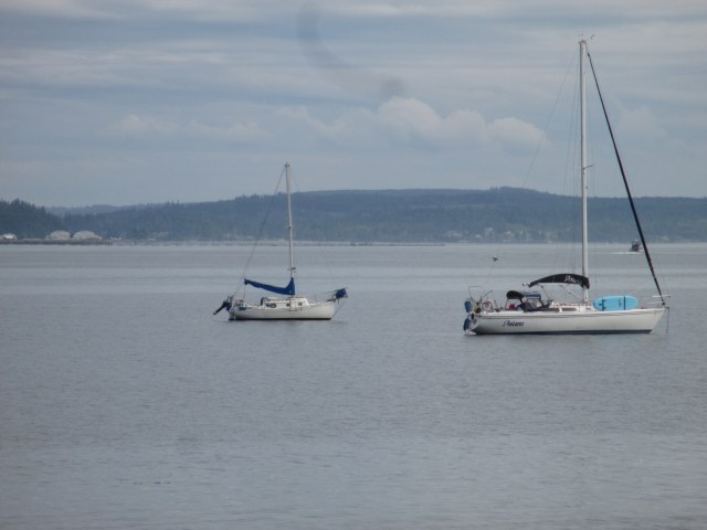
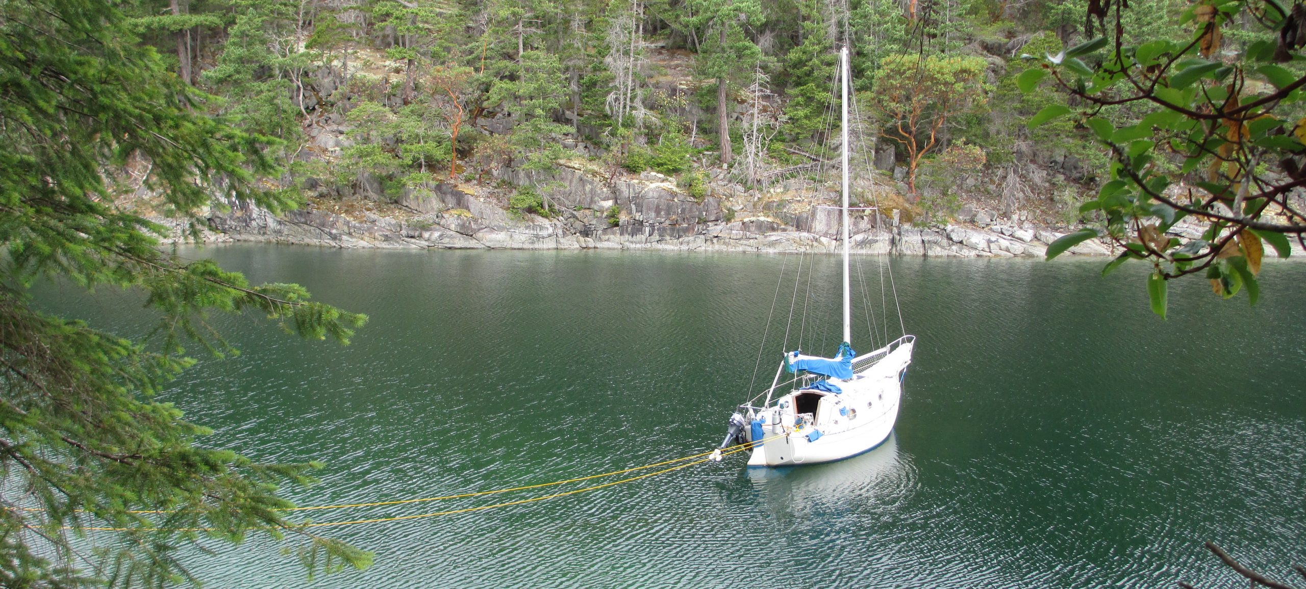
Sampaguita at rest in Port Townsend. 40-50 ft depth with 250 ft of rode.
Discover more from Sailing With Josh
Subscribe to get the latest posts sent to your email.


